Road safety is a high priority of the Municipality of Brighton.
Responsibilities
The Public Works Department is responsible for:
- Asphalt Patching
- Bridges and Culverts
- Crossing Guards
- Ditch Cleaning
- Dust Control
- Grass Cutting
- Gravel and Grading
- Line Painting
- Municipal Drains
- Patrolling
- Potholes
- Road Closures
- Sidewalks
- Signs and safety devices
- Snow Removal
- Street Lights
- Street Sweeping
- Traffic Signs
- Tree removal, brushing and trimming on municipal property
Municipal Roads
Routine scheduled maintenance is regularly performed as required. Deficiencies reported by the public are repaired on a priority basis. If you have any questions about what maintenance will be performed on your road this year, please contact the Public Works office at 613-475-1162.
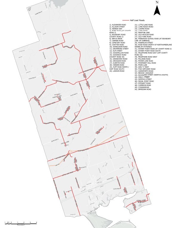
County Roads
For information on, or to report issues about (CR) County Roads (CR2, CR21, CR26, CR27, CR29, CR30, CR41, CR64), please contact Northumberland County at 1-800-354-7050.
Winter Operations & Snow Plowing
The Municipality of Brighton maintains over 250km of roads and 40km of sidewalks during winter operations using 10+ dedicated pieces of equipment for snow removal.
During winter weather events, our Roads Department is responsible for:
- plowing and salting roads,
- snow removal at Municipal buildings and parking lots,
- sidewalk plowing and,
- the removal of snow from Downtown
All municipal roads are divided into road classes based on traffic volumes and posted speed limits. The Municipality of Brighton has 4 different classes of roads within its boundaries based on these classifications. Class 2 roads have the highest priority with the most vehicles travelling on them. Class 5 roads are lightly travelled and have lower priority.
The Roads Department monitors 4 weather reports each day and does continuous road patrols to know when to dispatch snowplows. Plows are dispatched based on deteriorating road conditions and accumulation as outlined by the O.Reg. 239/02 Minimum Maintenance Standards (MMS) and listed in the chart below:
Minimum Maintenance Standards (MMS) for Winter Operations
Road Class | Depth of Snow Accumulation | Timeframe for Clearing Snow |
Class 2 |
5 cm |
6 hours |
Class 3 |
8 cm |
12 hours |
Class 4 |
8 cm |
16 hours |
Class 5 |
10 cm |
24 hours |
Declaring a “Significant Weather Event”
When the Municipality of Brighton is experiencing weather that may affect the ability of our Roads Department to maintain the roads at the service levels that road users would normally expect, we will declare a Significant Weather Event. As per the Ontario Municipal Act, a municipality may declare a significant weather event when a weather hazard, either forecasted or occurring, has the potential to pose a significant danger to users of the roadways in which they have authority.
The declaration of this event will be published on our website and social media channels and also pushed out to key stakeholders in the community.
Driving in the Snow
During poor driving conditions, unnecessary travel is not recommended.
If you do find yourself needing to travel in less than ideal conditions:
- Monitor highway and road conditions before your departure – check Ontario 511 for up to date traffic information
- Clear your car of snow and ice before driving
- Drive for the conditions – give yourself extra travel time, extra space to stop, go slow, keep a safe distance between cars, be patient
- Never attempt to pass a working snow plow
- Be prepared in case of emergency – prepare and have accessible a 72-hour survival kit, have your communication devices fully charged, download the what3words app to help emergency crews locate you within 3m of accuracy
Illegal Dumping on Roadsides
Illegal dumping should be reported to the Northumberland County Waste Management Department at:
555 Courthouse Road
Cobourg, ON K9A 5J6
Tel: 1-866-293-8379
Sidewalks
The Municipality of Brighton maintains approximately 42 kilometres of sidewalk. Repairs to damaged sidewalks will be undertaken by the Municipality in accordance with established standards. Each year major sections of deficient sidewalks and curb are replaced and upgraded to meet the Municipality's commitment to higher standards of accessibility. The Municipality recommends the removal of all objects beyond the property line and within 30 cm (18") of a municipal sidewalk. These objects include:
- wood,
- concrete,
- sprinkler systems;
- brick driveway edging,
- hedges or shrubs,
- fences, and
- flower beds
Parking Lots
The Municipality of Brighton currently operates 6 municipal Parking Lots in the downtown, all of which are free. Long term overnight parking is not allowed as these car parks are intended for customers and employees at our local businesses.
Street Lighting
The Municipality of Brighton has approximately 850 light standards and luminaires, which were converted to LED in 2016. Please report any street light malfunctions to the Municipality of Brighton, Public Works Department 613 475 1162.
2021 Capital Programs and Projects
The Municipality of Brighton's 2021Capital and Operating Budgets will fund new roads and sidewalk projects as well as continued maintenance to roads and sidewalks to ensure the safety of residents and visitors.
Below offers information on 2021 Capital Programs and Projects, in an effort to keep the general public informed of Municipal Infrastructure related projects and programs.
7 Year Proposed Surface Treatment Plan
2020 Program |
Street Name |
Section |
Approx. Length (km) |
Approx. Area (m²) |
From |
To |
Single Surface Treatment |
Bayshore Road |
Lighthouse Ln |
End |
4.00 |
|
Stoney Point Rd South |
Bayview Lane |
Boundary |
3.60 |
|
Shoal Point Rd |
Stoney Point Rd South |
End |
0.80 |
|
|
|
|
|
|
Double Surface Treatment |
Boundary Road |
Little Lake Rd |
0.7 km north of Hwy 2 |
1.70 |
|
Stoney Point Road |
CR 2 |
CR 64 |
2.40 |
|
Old Wooler Road |
CR 30 |
Lord |
5.30 |
|
Pinewood School Rd |
Goodrich Rd |
Boundary Rd |
2.30 |
|
Simpson St |
CR 2 |
End |
1.30 |
|
Tee's Ln |
Little Lake Rd |
End |
0.20 |
|
|
|
|
|
|
|
|
|
21.60 |
|
|
2021 Program |
Street Name |
Section |
Length (km) |
Approx. Area (m²) |
From |
To |
Single Surface Treatment |
Little Lake Rd |
Boundry Rd |
Tee's Ln |
3.25 |
23400 |
Hunt Ln |
Drummond St |
End |
0.12 |
864 |
Towerline Rd |
Old Wooler Rd |
CR 30 |
0.64 |
4608 |
Elm St |
CR 30 |
King St |
0.10 |
720 |
Bryce Dr |
CR 41 |
End |
0.30 |
2160 |
Wood St |
Bryce Dr |
End |
0.08 |
540 |
Hazle St |
Bryce Dr |
End |
0.10 |
720 |
King St |
Elm St |
Robinson |
0.24 |
1728 |
Lawson Rd |
CR 64 |
Lawson Settlement Rd |
1.55 |
11160 |
Lawson Settlement Rd |
Stoney Point Rd |
CR 2 |
1.45 |
10440 |
Robinson St |
CR 30 |
King St |
0.10 |
720 |
Grosjean Rd |
Old Wooler Rd |
CR 41 |
1.20 |
8640 |
Scriver Rd |
Telephone Rd |
Smith St |
2.40 |
17280 |
|
|
Total |
11.53 |
82980 |
Double Surface Treatment |
Lilac Ln |
Bayshore Rd |
End |
0.28 |
2016 |
Hillview Rd |
Boundry Rd |
End |
0.25 |
1800 |
Chatten Rd |
CR 30 |
Carmon rd |
2.80 |
20160 |
Florence Rd |
Chatten Rd |
End |
0.13 |
936 |
Scriver Rd |
Identified sections between Telephone Rd & Smith St |
0.90 |
6480 |
Vicari Rd |
CR 2 |
End |
0.17 |
1224 |
Huff Rd South |
Train Tracks |
bend at Popham Ln |
2.40 |
17280 |
Pinewood School Rd |
Goodrich Rd |
Loomis Rd |
2.30 |
16560 |
|
|
Total |
9.23 |
66456 |
|
2022 Program |
Street Name |
Section |
Length (km) |
Approx. Area (m²) |
From |
To |
Single Surface Treatment |
Lakehurst St |
Lakeshore Rd |
Lakeshore Rd |
0.40 |
2880 |
Lakeshore Rd |
Kelly Ln |
Presqu'ile Parkway |
2.60 |
18720 |
Greenway Circle |
Lakeshore Rd |
Lakshore Rd |
0.80 |
5760 |
Geogina St |
Hardy Ln |
Whites Rd |
1.40 |
10080 |
Fish Hatchery Rd |
CR 27 |
End |
0.90 |
6480 |
Telephone Rd West |
CR 30 |
Waites Rd |
2.90 |
20880 |
|
|
Total |
9.00 |
64800 |
Double Surface Treatment |
Lakecrest Circle |
Lakeshore Rd |
Lakeshore Rd |
0.50 |
3600 |
Huff Rd |
Tracks |
CR 2 |
2.00 |
14400 |
Huff Rd North |
CR 2 |
End |
0.60 |
4320 |
Waite's Rd |
Telephone Rd |
CR 21 |
1.90 |
13680 |
Percy St |
CR 2 |
End |
0.80 |
5760 |
Long Reach Rd |
CR 26 |
End |
1.20 |
8640 |
Walt St |
Smith St |
Whites Rd |
1.00 |
7200 |
|
|
Total |
8.00 |
57600 |
|
2023 Program |
Street Name |
Section |
Length (km) |
Approx. Area (m²) |
From |
To |
Single Surface Treatment |
Guertin Rd |
CR 30 |
End |
0.70 |
5040 |
Bullis Rd |
Telephone Rd |
200m North of Whites Road |
1.90 |
13680 |
Old York Rd |
CR 2 |
Oak Ridge Rd |
0.20 |
1440 |
Oakridge Drive |
Old York Rd |
End |
0.30 |
2160 |
Grandview Rd |
CR 2 |
End |
0.20 |
1440 |
Twin Ln |
CR 30 |
Richmond St |
0.10 |
720 |
Township Hall Rd |
Chattan Rd |
CR 30 |
0.20 |
1440 |
Florence Rd |
Chatten Rd |
End |
0.10 |
720 |
Bonn Rd |
Smith St |
End |
1.00 |
7200 |
Hanson Rd |
CR 30 |
CR 26 |
3.40 |
24480 |
|
|
Total |
8.10 |
58320 |
Double Surface Treatment |
Carman Rd |
CR 30 |
CR 26 |
2.50 |
18000 |
Carman Rd |
CR 26 |
Coltman Rd |
5.30 |
38160 |
Young St |
0.3km N of George St |
End |
0.30 |
2160 |
|
|
Total |
8.10 |
58320 |
|
2024 Program |
Street Name |
Section |
Length (km) |
Approx. Area (m²) |
From |
To |
Single Surface Treatment |
Newton Ln |
CR 30 |
End |
0.50 |
3600 |
Cemetary Rd |
CR 30 |
Richmond St |
0.50 |
3600 |
Alexander Rd |
CR 30 |
Little Lake Rd |
0.80 |
5760 |
|
|
Total |
1.80 |
12960 |
Double Surface Treatment |
Telephone Rd |
CR 26 |
QW Boundry |
7.00 |
50400 |
Old Wooler Rd |
Lord Rd |
QW Boundry |
5.10 |
36720 |
Rush Rd |
CR 41 |
Hansen Rd |
1.20 |
8640 |
Lord Rd |
CR 41 |
Old Wooler Rd |
1.20 |
8640 |
|
|
Total |
14.50 |
104400 |
|
2025 Program |
Street Name |
Section |
Length (km) |
Approx. Area (m²) |
From |
To |
Single Surface Treatment |
|
|
|
|
Richmond St South |
CR 21 |
Endnd (South) |
1.00 |
|
Moran Dr |
Richmond St |
Richmond St |
0.50 |
|
Middle Ridge Rd |
Telephone rd |
End |
1.10 |
|
Goodrich Rd |
CR 30 |
Sumach Ln |
2.00 |
|
Loomis Rd |
Pinewood School Rd |
CR 30 |
2.90 |
|
Whites Rd |
Scriver Rd |
0.5KM west of Scriver Rd |
0.50 |
|
Double Surface Treatment |
|
|
|
|
Richmond St |
CR 21 |
End (North) |
4.50 |
|
Sumach |
Goodrich Rd |
End |
0.85 |
|
Cramahe Hill Rd |
Pine Grove Rd |
CR 27 |
3.10 |
|
Cameron Rd |
Goodfellow Rd |
0.5 S of Goodfellow Rd |
0.50 |
|
|
|
Total |
16.95 |
|
|
2026 Program |
Street Name |
Section |
Length (km) |
Approx. Area (m²) |
From |
To |
Single Surface Treatment |
|
|
|
|
Cowan Rd |
Old Wooler Rd |
Jamison Rd |
0.90 |
|
Laird Nelson Rd |
Old Wooler Rd |
Deadend |
0.20 |
|
Percy Boom Rd |
CR 29 |
Boundary Rd |
1.00 |
|
Jamison Rd |
Cowan Rd |
Dalmas Rd |
2.45 |
|
Donaldson Rd |
CR 30 |
Deadend |
1.30 |
|
Stewart Rd |
CR 64 |
Martin Rd |
0.60 |
|
Martin Rd |
Stewart Rd |
Deadend |
0.20 |
|
Cedardale Rd |
Stoney Point Rd South |
Deadend |
0.40 |
|
Tillings Rd |
CR 30 |
Deadend |
0.50 |
|
Double Surface Treatment |
|
|
|
|
Aranda Way |
Goodfellow Rd |
CR 30 |
5.50 |
|
Bauer Rd |
Telephone Rd |
Deadend |
0.30 |
|
Allison St |
CR 30 |
Deadend |
0.50 |
|
Goodfellow Rd |
CR 30 |
Cameron Rd |
2.30 |
|
Stone Ln |
Hansen Rd |
End |
0.15 |
|
Lisgar |
CR2 |
Smith St |
0.62 |
|
|
|
Total |
16.15 |
|
|
2027 Program |
Street Name |
Section |
Length (Km) |
|
From |
To |
|
Single Surface Treatment |
Bayshore Road |
Lighthouse Ln |
End |
4.00 |
|
Stoney Point Rd South |
Bayview Lane |
Boundary |
3.60 |
|
Shoal Point Rd |
Stoney Point Rd South |
End |
0.80 |
|
|
|
|
|
|
Double Surface Treatment |
Boundary Road |
Little Lake Rd |
0.7 km north of Hwy 2 |
1.70 |
|
Stoney Point Road |
CR 2 |
CR 64 |
2.40 |
|
Old Wooler Road |
CR 30 |
Lord |
5.30 |
|
Pinewood School Rd |
Loomis Rd |
Municipal Boundary |
1.5 |
|
Simpson St |
CR 2 |
End |
1.30 |
|
Tee's Ln |
Little Lake Rd |
End |
0.20 |
|
|
|
|
|
|
|
|
|
21.60 |
|
|
6 Year Proposed Construction Plan
Proposed 2021 Plan |
Street Name |
Section |
Length (m) |
Constr. Year |
Scope of Work |
Budget (Construction Year Dollars) |
Total Budget ($) |
From |
To |
Road ($) |
Water ($) |
Sanitary ($) |
Storm ($) |
Telephone Rd |
County Road 30 |
County Road 26 |
2,110 |
2021 |
Reconstruction Road only |
963,678 |
|
|
|
963,678 |
Loyalist Drive |
Prince Edward Street |
Applewood Drive |
431 |
2021 |
Road reconstruction, water, sanitary, and storm services |
762,000 |
120,000 |
70,000 |
87,000 |
1,039,000 |
Pumping Station & Forcemain |
|
|
|
2021 |
Reconstruction of the pumping station and twinning of the forcemain |
|
|
3,000,000 |
|
3,000,000 |
Chlorine Booster Station |
232 Presqu'lle Parkway |
|
|
2021 |
Removal from system. |
|
10,000 |
|
|
10,000 |
2" Service |
County Road 30 @ Spring Valley |
|
|
2021 |
Replace outdated infrastructure. |
|
40,000 |
|
|
40,000 |
MBBR |
|
|
|
2021 |
Construction of an MBBR facility |
|
|
8,800,000 |
|
8,800,000 |
Subtotals 2021 |
1,725,678 |
170,000 |
11,870,000 |
87,000 |
13,852,678 |
|
Proposed 2022 Plan |
Street Name |
Section |
Length (m) |
Constr. Year |
Scope of Work |
Budget (Construction Year Dollars) |
Total Budget ($) |
From |
To |
Road ($) |
Water ($) |
San. ($) |
Storm ($) |
Prince Edward Street |
Elizabeth Street |
Harbour Street |
1,900 |
2022 |
Reconstruction, Brighton water, sanitary. NC responsible for road and storm |
|
1,749,444 |
1,809,940 |
|
3,559,384 |
Lakeview Heights Booster Station |
|
|
|
2022 |
Upgrading infrastructure. |
|
6,000 |
|
|
6,000 |
Subtotals 2022 |
|
1,755,444 |
1,809,940 |
|
3,565,384 |
|
Proposed 2023 Plan |
Street Name |
Section |
Length (m) |
Constr. Year |
Scope of Work |
Budget (Construction Year Dollars) |
Total Budget ($) |
From |
To |
Road ($) |
Water ($) |
San. ($) |
Storm ($) |
Pinnacle Street South |
Elizabeth Street |
End |
300 |
2023 |
Road reconstruction, water, sanitary, and storm services |
435,351 |
276,228 |
285,780 |
214,188 |
1,211,547 |
Presquile Parkway |
Ontario Street |
Park Entrance |
1,150 |
2023 |
Reconstruction Road only |
1,150,000 |
|
|
|
1,150,000 |
2 Turbidity Analyzers |
Water Treatment Plant |
|
|
2023 |
Upgrading infrastructure |
|
8,000 |
|
|
8,000 |
Subtotals 2023 |
1,585,351 |
284,228 |
285,780 |
214,188 |
2,369,547 |
|
Proposed 2024 Plan |
Street Name |
Section |
Length (m) |
Constr. Year |
Scope of Work |
Budget (Construction Year Dollars) |
Total Budget ($) |
From |
To |
Road ($) |
Water ($) |
San. ($) |
Storm ($) |
Main Street |
Ontario Street |
Rundle Lane |
835 |
2024 |
Road reconstruction, water, sanitary, and storm services |
1,857,318 |
1,178,076 |
1,218,914 |
913,410 |
5,167,718 |
Flow Meters (PW1, PW2, PW3, & Final) |
|
Water Treatment Plant |
|
2024 |
Upgrading infrastructure |
|
16,000 |
|
|
16,000 |
Subtotals 2024 |
1,857,318 |
1,194,076 |
1,218,914 |
913,410 |
5,183,718 |
|
Proposed 2025 Plan |
Street Name |
Section |
Length (m) |
Constr. Year |
Scope of Work |
Budget (Construction Year Dollars) |
Total Budget ($) |
From |
To |
Road ($) |
Water ($) |
San. ($) |
Storm ($) |
Main Street |
Prince Edward Street |
Ontario Street |
815 |
2025 |
Road reconstruction, water, sanitary, and storm services |
1,182,704 |
750,419 |
776,369 |
581,877 |
3,291,369 |
Flow Control Valve (PW1, PW2, & PW3) |
|
Water Treatment Plant |
|
2025 |
Upgrading infrastructure |
|
13,500 |
|
|
13,500 |
Subtotals 2025 |
1,182,704 |
763,919 |
776,369 |
581,877 |
3,304,869 |
|
Proposed 2026 Plan |
Street Name |
Section |
Length (m) |
Constr. Year |
Scope of Work |
Budget (Construction Year Dollars) |
Total Budget ($) |
From |
To |
Road ($) |
Water ($) |
San. ($) |
Storm ($) |
Applewood Drive |
Loyalist Drive |
End (North) |
330 |
2026 |
Road reconstruction, water, sanitary, and storm services |
478,886 |
108,500 |
106,429 |
85,000 |
778,815 |
Pressure Reducing Valve |
3 Baldwin Street |
|
|
2026 |
Upgrading infrastructure |
|
130,000 |
|
|
130,000 |
Pressure Reducing Valve |
Ontario Street |
|
|
2026 |
Upgrading infrastructure |
|
130,000 |
|
|
130,000 |
Pressure Reducing Valve |
3 Morow Avenue |
|
|
2026 |
Upgrading infrastructure |
|
130,000 |
|
|
130,000 |
Subtotals 2026 |
478,886 |
498,500 |
106,429 |
85,000 |
1,168,815 |
|
Web map of planned sidewalk and road capital projects for 2021
AODA Compliant Sidewalk Plan Map